Shopping waterfront in Anna Maria and seeing the phrase “sailboat water” everywhere? It sounds simple, but the meaning can vary from listing to listing. If you want real access for your boat, you need more than a catchy phrase. In this guide, you’ll learn what “sailboat water” really means on Anna Maria Island, how tides and bridges affect your route, and the exact checks to do before you buy or sell. Let’s dive in.
What sailboat water means
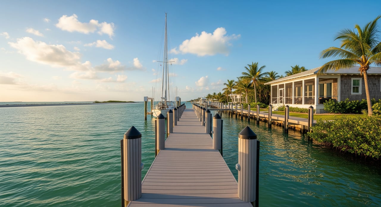
“Sailboat water” is marketing shorthand, not a legal term. In practice, it means the water at or near a property is navigable by sailboats with a safe route to open water. What matters is how your boat fits the setting.
Key components to confirm:
- Depth at the dock and along the route compared with your boat’s draft.
- Vertical clearance for your mast and rigging under bridges or overhead lines.
- Waterway width and turning room so you can maneuver a sailboat safely.
- Connection to a maintained channel that leads to Tampa Bay, the Intracoastal, or the Gulf.
Boat needs vary. Centerboard and dinghy sailboats draw roughly 0 to 2 feet. Smaller keelboats often draw 3 to 6 feet. Larger cruisers may draw 6 to 8 feet or more. Mast height also ranges widely, so bridge clearance must match your specific air draft. Use these numbers only as planning guides and always verify for your boat.
Anna Maria water realities
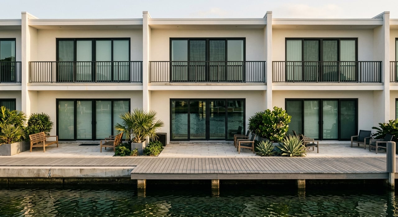
Anna Maria is a barrier island with two very different faces. Gulf-side beachfront is about waves and views, not private docks. Most private docks and canals are on the bay and interior sides, feeding toward Tampa Bay or the Gulf Intracoastal Waterway. Canal depths and access routes vary by neighborhood.
Local tides are modest, but low tide can reduce depth at private docks. Many small canals are not maintained and can shoal over time. The Gulf Intracoastal Waterway and federally maintained channels provide more reliable depth for larger vessels, though you still need to check the route from your dock to those channels.
Depth and tides
Depths in listings are sometimes quoted at Mean Low Water or Mean High Water. Ask which datum was used. Even a few inches can matter if your keel is deep. Seasonal shifts, storms and normal sediment movement can change depths, especially in smaller canals.
Routes to channels
Your access is only as good as the shallowest point between your dock and a maintained channel. Canals that feed directly to the Intracoastal generally offer more dependable depth than narrow, winding, or marsh-lined cuts. If dredging is needed to maintain usable depth, find out who pays and how often it has been done.
Bridges and clearance
Fixed bridge height and any overhead lines determine whether your mast can pass. Some approaches between the island and the mainland have limited clearance. Verify bridge heights for your complete route and note any drawbridge operations if applicable.
Buyer verification checklist
Use this step-by-step list during due diligence so you know exactly what you are getting.
- Confirm depth at the dock at both Mean Low Water and Mean High Water for accuracy.
- Check depth along the path from the dock to the nearest maintained channel, then to Tampa Bay, the Intracoastal or the Gulf.
- Verify all fixed bridge clearances and look for overhead cables on your route; note any drawbridge schedules.
- Ask if your route includes a federally or locally maintained channel and when it was last dredged.
- Request records of dock permits, seawall repairs, any dredging history and active permits.
- Verify riparian rights and whether a deeded dock or slip is included; review HOA rules if applicable.
- Confirm any local regulations for moorings, boat lifts, piling types and speed or no-wake zones.
- Review FEMA flood zone designation and obtain elevation certificates to estimate insurance and building requirements.
- Hire a marine surveyor or licensed contractor to inspect seawalls, pilings and dock condition; consider a hydrographic depth check if you have a deeper-draft boat.
- Call local marinas, harbormasters and boatyards for current on-the-water knowledge about shoaling and recommended routes.
Boat types and fit
Centerboard and dinghy sailors
If your draft is near 0 to 2 feet, many canals and slips will work for you. Still confirm low-tide depths and turning room, especially in narrow canals. Bridge clearance is usually easier, but verify mast height to be safe.
Small keelboats and cruisers
Drafts around 3 to 6 feet require careful vetting of both the dock and the canal path. Prioritize proximity to maintained channels. Confirm low-tide depths in any unmaintained canal and verify bridge clearances on your full route.
Larger keelboats and cruiser-racers
Drafts of 6 to 8 feet or more demand deeper water and wider canals. These boats benefit most from docks very close to maintained channels. Expect to complete a depth survey of the route and to validate every bridge clearance to the Gulf or Tampa Bay.
Costs, risk and insurance
Waterfront homes in this area are commonly in FEMA flood zones such as AE or VE. Exposure to wind-driven waves differs between open Gulf frontage and more sheltered bay or canal locations. Elevation certificates, seawall condition and storm-surge exposure influence homeowners’ and flood insurance costs.
If a canal requires periodic dredging to remain usable, understand potential assessments or owner costs. Seawall maintenance is another ongoing item. Build these numbers into your long-term budget alongside typical dock upkeep.
Seller tips for “sailboat water” listings
If you plan to market a property as sailboat friendly, specificity builds trust and value. Buyers will ask for proof.
- State approximate depth at Mean Low Water at the dock.
- Note the route to the Intracoastal or Tampa Bay and whether that route uses a maintained channel.
- Provide copies of permits for docks, lifts and seawall work, plus any dredging records.
- Disclose any known restrictions, HOA rules or maintenance obligations that affect access.
- Share recent inspections of seawalls, pilings and dock structure.
Clarity in your MLS copy helps qualified buyers engage faster and reduces the risk of disputes later.
Rules and permits to know
Waterfront work usually requires permits. In Florida, private docks, seawalls and boat lifts often need approvals from state and local agencies, and sometimes from the U.S. Army Corps of Engineers if navigable waters are involved. Riparian rights, setbacks and HOA covenants can also limit dock size or lift placement.
Environmental protections matter. Seagrass beds, mangroves and manatees are protected, and some areas carry slow-speed or no-wake rules that affect navigation. Dredging is tightly regulated and may be limited by season, habitat and permit conditions.
Bridge data and drawbridge schedules determine mast clearance. Municipalities may regulate private moorings or designate anchoring fields to protect seagrass. Check the City of Anna Maria, the City of Holmes Beach and the City of Bradenton Beach for local ordinances, and consult Manatee County for countywide environmental permitting.
Your action plan
- Define your boat’s exact draft and air draft.
- Walk the property at low tide and inspect the dock and seawall.
- Trace your route to a maintained channel and note any choke points.
- Validate bridge clearances and any drawbridge operations along the whole route.
- Review flood zone, elevation certificates and insurance estimates.
- Gather or request permits, maintenance records and any dredging history.
- Speak with local marinas and harbormasters about real-time conditions.
- Bring in a marine surveyor or dock contractor for a professional opinion.
Work with a waterfront specialist
On Anna Maria Island, “sailboat water” is about real access, not just a view. You deserve a partner who understands docks, seawalls, tides, bridge clearances and permitting, and who can coordinate the right inspections and surveys. Costa Living blends certified waterfront expertise with concierge-level service, so you can buy or sell with confidence and clarity.
If you are planning a move or prepping a listing, connect with Jo-Lee Mansfield to discuss your goals and get a tailored sailboat access plan.
FAQs
What does “sailboat water” mean for Anna Maria buyers?
- It means a listing claims usable sailboat access, but you should verify depth at low tide, an unobstructed route to a maintained channel and sufficient bridge clearance for your mast.
How do I verify depth and bridge clearance before closing?
- Confirm dock and route depths at Mean Low Water, check bridge data for your entire path, and hire a marine surveyor or dock contractor for on-site measurements.
Are Gulf-side homes usually sailboat friendly on Anna Maria?
- Most private docks and sailboat access are on bay and interior waterways, while Gulf-side frontage is typically about shoreline and views rather than dockage.
What permits are needed to build or modify a dock?
- Expect state and local permits and sometimes U.S. Army Corps authorization, with rules that account for riparian rights, setbacks and environmental protections.
How do tides affect access at private docks on the island?
- The local tidal range is modest, but low tide can reduce usable depth at docks and along canals, so you should confirm depths using the correct tidal datum.
What insurance factors should I consider for sailboat-access homes?
- Flood zone designation, elevation certificates, seawall condition and exposure to wind-driven waves influence homeowners’ and flood insurance pricing and requirements.